Classification scenarios
There are 6 classification scenarios embedded within OFT presenting different aspects of a Natura 2000 site classification:
- land cover
- main vegetation categories / alkali sub-habitats
- alkali vegetation associations
- anthropogenic features and disturbances
- trees and shrubs
- invasive species
Site overview map with clickable regions of interest

Every scenario is shown on an overview map, with pre-defined regions of interest marked as clickable rectangles. Clicking a region of interest opens a detailed view page with different visualizations of the area, presented in a much more detailed resolution (in this case 0.5 m pixel size), or other detail pages – depending on the type of region. Overview map in every scenario is shown using different color schemes – to make scenarios more visually distinctive.
Training & reference data
Samples of ground-truth data including photos collected during field work campaigns are shown.
Input rasters – FWF-ALS / LiDAR derivatives
For areas of interest samples of all input rasters with ALS derivatives / variables are presented. These are the rasters derived from full wave-form ALS sensor data, which – together with reference data – form the main input for the classifier.
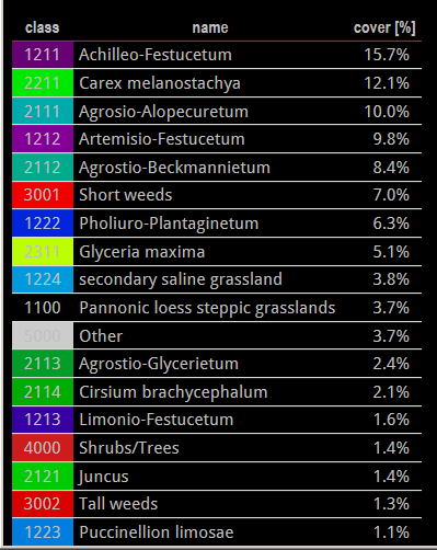
List of class structure
This display shows class structure of a scenario with class names and identification numbers, colors used to represent respective class on map renderings, and optionally a percentage of cover of a given class within a map fragment (or global site area).